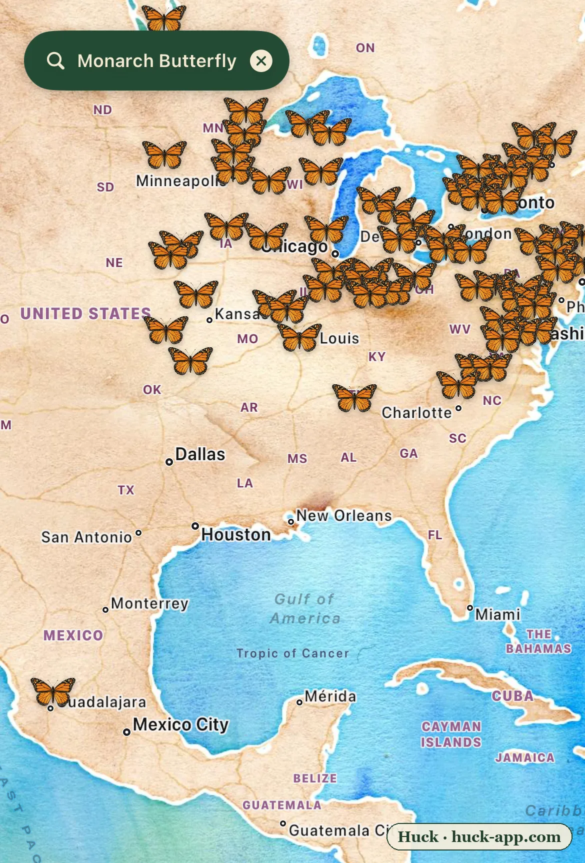
The map above is a migration in progress. Every orange mark is a recent, verified monarch sighting, and right now, in late summer, they are pointed in one direction: south. The dense band across the Midwest and the Northeast is the last breeding generation of the year. That lone cluster far to the south, near the mountains west of Mexico City, is where almost all of them are trying to go. Between those two points is one of the most improbable journeys in nature, and a federal decision that will help determine whether it keeps happening.
The most improbable commute on the continent
No single monarch makes the round trip. The butterflies breeding in Ohio and Ontario this month are three or four generations removed from the ones that left Mexico in the spring, each earlier generation living only a few weeks, mating, laying eggs on milkweed, and dying somewhere a little farther north. Then, as the days shorten, something flips. The monarchs emerging now are different: they will not breed this year. This is the super-generation, and instead of a few weeks it will live eight months. It will fly as far as 3,000 miles, to a forest it has never seen, and cluster by the millions on the exact same oyamel firs its great-great-grandparents used. Nobody fully understands how they find it.
The butterfly flying over your yard this week may end its life on a mountaintop in Mexico it has no way of knowing exists.
The collapse
For most of the twentieth century this was a story of abundance. It is not anymore. The eastern migratory population, the one on this map, has fallen by roughly 80 percent since the 1990s, measured by the area of Mexican forest the overwintering butterflies cover. The western population, which winters on the California coast instead of Mexico, has crashed by more than 95 percent since the 1980s, and by some estimates faces a greater than 99 percent chance of collapse by 2080.
The causes stack. The single biggest is the loss of milkweed, the only plant monarch caterpillars can eat, across the farm belt as herbicide-tolerant crops let growers clear it from hundreds of millions of acres. Add habitat loss along the route, a changing climate that scrambles the timing of the whole relay, and logging and heat at the Mexican wintering grounds, and the migration has been squeezed from every side at once.
The fight the map is about
In December 2024, after years of review, the US Fish and Wildlife Service formally proposed listing the monarch as threatened under the Endangered Species Act, with a special rule to allow ordinary gardening and farming to continue, plus protected overwintering habitat on the California coast. Then it stalled. As of this writing the final rule still has not been issued; the agency has reclassified it as a long-term action, pushing any decision to the fall of 2026 at the earliest. So the monarch sits in an unusual limbo: proposed for federal protection, championed by groups like the Xerces Society and Monarch Watch, and still waiting, while the population it would protect keeps shrinking and the butterflies on this map keep flying south without it.
What the community data shows, and what it does not
This map is built from hundreds of thousands of research-grade monarch observations logged by ordinary people on iNaturalist. Monarchs are among the most-watched insects on Earth, which is exactly why the pattern is so legible: the late-summer breeding range lights up, and the migratory funnel toward Mexico is visible in near real time.
It is worth being clear about what community sightings can and cannot say. They are a map of where people are looking as much as where monarchs are, and a busy map does not mean a healthy population. The real population numbers come from a different measure entirely: biologists count the hectares of Mexican forest the overwintering colonies cover each winter, and tally the western butterflies at their California groves. Those counts are what show the 80 and 95 percent declines. What the sightings add is the living shape of the thing at risk, the migration as it actually moves, which no single census can picture.
The one thing that actually helps
Most conservation problems are too big for an individual to touch. This one is unusual. Because the bottleneck is milkweed, a yard, a roadside, or a schoolyard planted with the native milkweed for your region is not a symbolic gesture, it is breeding habitat the caterpillars can literally use, and enough of them stitched together is a migration corridor. Plant the species native to your area rather than tropical milkweed, which can do more harm than good. And if you see a monarch, log it: the map on this page exists because people did, and those records are part of how the decline gets measured and argued in the first place.
About the data
Sightings shown are research-grade community observations from iNaturalist, mapped in Huck; counts are current as of August 2026 and monarch coordinates are not obscured. Population trend figures come from long-term overwintering surveys: the World Wildlife Fund and Mexican partners for the eastern colonies, and the Xerces Society Western Monarch Count for the California population. Listing status reflects the US Fish and Wildlife Service proposed rule of December 2024 and its subsequent delay.